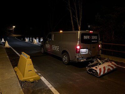
From designating utilities and subsurface obstructions through quality level B (QL-B) mapping, to concrete scanning and test pit clearance surveys, Infrasense has been utilizing our advanced 3D ground penetrating radar scanning technologies for various subsurface mapping projects across Massachusetts and beyond.
WOBURN, Mass., Aug. 8, 2025 /PRNewswire/ — Infrasense has been putting our advanced 3D ground penetrating radar (3DGPR) scanning vehicle to work this summer with subsurface mapping projects across Massachusetts and the surrounding New England area. We often utilize 3DGPR for projects where the target conditions and objectives of the survey require exceptional spatial precision, which is the case when mapping utilities. The 3DGPR system, like other GPR systems employed by Infrasense, can be mounted to a survey vehicle. This enables data collection to be carried out at driving speeds, so lane closures are not required, and traffic is uninterrupted. Collected 3DGPR data is combined with as-built records, surveyed locations of utility features, and EMI-based utility mark-outs to produce accurate and comprehensive maps.
With each project also comes new discoveries and insights for our engineers and clients alike. Our combination of 3DGPR and electromagnetic induction (EMI) techniques has consistently delivered higher confidence results than with either method alone. One reason why clients may find 3DGPR methods particularly valuable is the clarity and continuity of the data. GPR can detect the interface between different materials, such as the buried utility lines (metal, plastic, other) and the surrounding subgrade material. The contrast at the interface of the different materials provides an identifiable feature in the data which, when it appears in successive adjacent cross sections, can be identified as a utility. Because 3DGPR collection and analysis techniques are so comprehensive, especially when used in combination with EMI, there are instances where discovery of additional significant subsurface elements occurs. This could mean anything from other utilities, or something more complex, such as when our analysis of 3D array GPR determined the location of former trolley lines during a review of the near surface depth slices.
If you want to learn more about our 3DGPR technology and subsurface mapping services, please visit our website at www.infrasense.com or feel free to contact us at opps@infrasense.com.
About Infrasense, Inc.
Since 1987, Infrasense, Inc. has applied advanced technologies to address the most difficult challenges in subsurface scanning. Infrasense’s engineers nondestructively extract critical information from a diverse range of structures. In addition to providing ongoing subsurface evaluation services to clients across the country, the firm has also conducted numerous research programs to advance the field of subsurface detection and nondestructive evaluation.

